National

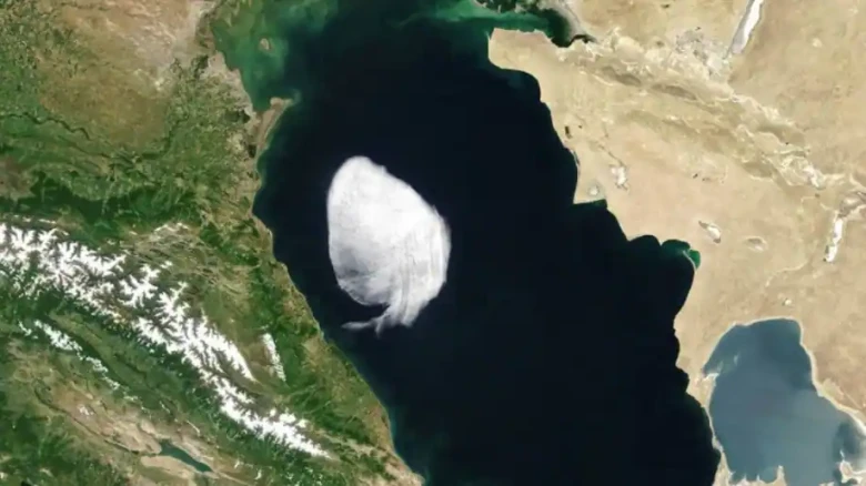
The stratocumulus cloud in the image has developed a 100-kilometer-long layer. Typically, these clouds occur at low elevations, between 600 and 2,000 metres above the earth. The one in the photo was most likely hanging at 1,500 metres in altitude.
"Times New Roman";color:#3E3E3E;mso-fareast-language:EN-IN">Digital Desk:
Clouds are frequently seen hovering over the Caspian Sea, the world's biggest
inland body of water. However, NASA's Moderate Resolution Imaging
Spectroradiometer (MODIS) discovered a strangely structured cloud travelling
across the water body on May 28. In dramatic contrast to the ordinary diffused
and dispersed cloud cover, the cloud had well-defined edges resembling
something from a cartoon or something painted onto the countryside.
"Times New Roman";color:#222222;mso-fareast-language:EN-IN">
"Times New Roman";color:#3E3E3E;mso-fareast-language:EN-IN">The cloud is a
small stratocumulus cloud, according to Bastiaan van Diedenhoven, an
atmospheric scientist at SRON Netherlands Institute for Space Research. Cumulus
clouds are detachable "heaps" of "cauliflower-shaped"
clouds that can be seen during favourable weather. In stratocumulus clouds,
these heaps are clumped together, forming a widespread horizontal layer of
clouds.
mso-fareast-font-family:"Times New Roman";color:#222222;mso-fareast-language:
EN-IN">
"Times New Roman";color:#3E3E3E;mso-fareast-language:EN-IN">
"Times New Roman";color:#3E3E3E;mso-fareast-language:EN-IN">The stratocumulus
cloud in the image has developed a 100-kilometer-long layer. Typically, these
clouds occur at low elevations, between 600 and 2,000 metres above the earth.
The one in the photo was most likely hanging at 1,500 metres in altitude.
"Times New Roman";color:#222222;mso-fareast-language:EN-IN">
"Times New Roman";color:#3E3E3E;mso-fareast-language:EN-IN">The cloud was over
the centre Caspian in the late morning when the photo was taken. It had
travelled northwest by the afternoon and was poised above the central Caspian.
By the afternoon, it had moved northwest and was hugging the shore of
Makhachkala, Russia, in a low-lying plain near the Caucasus Mountains'
foothills.
mso-fareast-font-family:"Times New Roman";color:#222222;mso-fareast-language:
EN-IN">
mso-fareast-font-family:"Times New Roman";color:#3E3E3E;mso-fareast-language:
EN-IN">The cloud could have developed over the Caspian when warm, dry air
collided with colder, moister air, according to van Diedenhoven. It could then
have drifted across the water before dissipating when it came to rest on shore.
mso-hansi-font-family:Calibri;mso-bidi-font-family:Calibri;color:#222222;
mso-fareast-language:EN-IN">
mso-fareast-font-family:"Times New Roman";color:#3E3E3E;mso-fareast-language:
EN-IN">"When dry, warm air from the land collides with cooler, moister air
over the ocean, sharp edges are frequently formed, and the cloud forms at that
boundary." "You commonly see this off the west coast of Africa, but
on considerably greater sizes," van Diedenhoven said in a news release,
explaining how the cloud's formation also explains its sharp edges.
mso-hansi-font-family:Calibri;mso-bidi-font-family:Calibri;color:#222222;
mso-fareast-language:EN-IN">
color:#222222;mso-fareast-language:EN-IN">
color:#222222;mso-fareast-language:EN-IN">
mso-fareast-language:EN-IN">
Leave A Comment