
International
A nine-day mourning period will now begin, after which the College of Cardinals will gather in conclave to elect the next Pontiff.
Digital Desk: The 266th leader of the Roman Catholic Church, Pope Francis, died peacefully in his resi

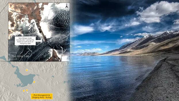
Digital Desk: China is building a bridge in Eastern Ladakh that will connect the North and South Banks of the Pangong Tso for the People's Liberation Army (PLA) to move troops and equipment between the two sectors as per official sources.
"A PLA garrison is stationed at Kurnak fort on the North Bank, while another is stationed at Moldo on the South Bank; the distance between the two is around 200 kilometers. The new bridge, which spans 500 meters between the nearest places on both banks, will reduce travel time between the two regions from about 12 hours to 3-4 hours." sources quoted.
Notably, the bridge is around 25 kilometers ahead of the actual control line (LAC),
On the other hand, another government source said that the construction has been ongoing for some time and will lower the overall distance by roughly 140-150 kilometers.
Also Read: Covid Scare: Shillong Re-Imposes Covid Restrictions, Check Here for Details
Previously, the PLA had to use a roundabout to traverse Rudok County, but now the bridge will provide a direct axis, according to the first source.
Further, the source added that the new bridge's major advantage is the inter-sector movement, which will take substantially less time. It indicated that they need to construct piers for the bridge that has been under construction.
The source quoted that the bridge is on its turf, and the Indian Army will have to adjust its operational plans accordingly.
India owns a third of the 135-kilometer-long boomerang-shaped lake, which sits at the height of above 14,000 feet.
The conflicts began in early May 2020 on the North Bank, which has far greater variations in perceptions of LAC than the South Bank, while tensions on the South Bank blew up later in August.
In late August, the Indian Army acquired a tactical edge over the PLA on the south bank by seizing many heights that had been empty since 1962, giving it a commanding view over the Moldo area. Indian troops also set up stations on the north bank, facing PLA positions on the Finger 4 ridgelines.
Both sides agreed to complete disengagement on Pangong Lake's north and south banks as part of the first phase of disengagement in February 2020. The Indian Army has a permanent presence at Finger 3, the Dhan Singh Thapa garrison, and the PLA maintains a camp east of Finger 8. The Pangong River's South Bank goes to the Kailash Range and the Chushul Sector.
According to official reports, China has begun building alternate roadways away from our line of sight after the August action.
On the other hand, media reports said that China had intensified building activities behind the main confrontation points in Aksai Chin.
An open-source intelligence analyst with the Twitter handle @detresfa_ shared a satellite photograph of the location, revealing a bridge-like structure connecting the two banks' closest points.


Leave A Comment