Sea conditions are expected to be quite high along and off the shores of Kerala and Karnataka, as well as Lakshadweep and...
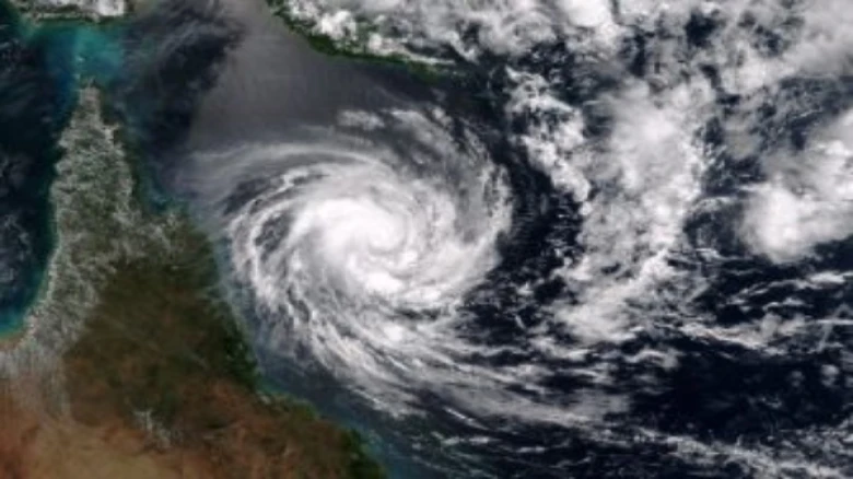
Digital Desk: India Meteorological Department issues reports stating, a deep depression over the southeast Arabian Sea strengthened into cyclonic storm 'Biparjoy' on Tuesday evening. Bangladesh gave the name 'Biparjoy' to the bird.
"At 1730 hours, the deep depression over the southeast and adjoining east-central Arabian Sea moved nearly northwards at a speed of 4 kmph, intensified into cyclonic storm 'Biparjoy' (pronounced as 'Biporjoy,' and lay centred about 920 km west-southwest of Goa, 1050 km southwest of Mumbai, 1130 km south-southwest of Porbandar, and 1430 km south of Karachi,"
It is expected to continue almost northward and gradually build into a very strong cyclonic storm.
On June 6, sea conditions are expected to be very high along and off the Kerala-Karnataka coastlines, as well as the Lakshadweep-Maldives area, and the Konkan-Goa-Maharashtra coasts from June 8 to June 10. Fishermen who are out at sea have been encouraged to return to shore.
According to the IMD, the emergence and deepening of a low-pressure system over the southeast Arabian Sea is predicted to have a significant impact on the monsoon's approach towards the Kerala coast.
However, the weather service did not provide an estimated date for the onset of the monsoon in Kerala.
A report from private forecasting firm Skymet Weather, the monsoon may arrive in Kerala on June 8 or June 9, although it will be a "meek and mild entry."
Skymet had previously projected the commencement of the monsoon over Kerala on June 7 with a three-day error margin.
"The southwest monsoon is expected to arrive within this time frame." Onset criteria call for specified rainfall over Lakshadweep, Kerala, and coastal Karnataka on two consecutive days. As a result, the spread and intensity of rainfall may meet these criteria on June 8 or June 9. However, the annual event's start may not be loud and clear. "It may make a meek and mild entry, to begin with," stated the private weather predicting firm.
Kerala had considerable rain on Monday as well, according to D S Pai, senior scientist at IMD, and conditions are conducive for the onset of monsoon over the next two to three days.
Rain will fall over the southern peninsula as a result of the cyclonic storm and a low-pressure system developing in the Bay of Bengal. However, as the cyclone degenerates, the monsoon will move beyond the southern peninsula, according to Pai.
Despite the emerging El Nino conditions, India is anticipated to receive normal rainfall throughout the southwest monsoon season, according to the IMD.
Rainfall in northwest India is forecast to be normal to below normal. The normal rainfall of 94-106 percent of the long-period average of 87 cm is forecast in the east and northeast, central, and south peninsulas.


Leave A Comment