
The average maximum, minimum, and mean temperatures for the entire nation during June 2022 were 34.12 degrees Celsius, 25.06 degrees Celsius, and 29.59 degrees Celsius, respectively, in contrast to the typical values of 33.73 degrees Celsius, 24.76 degrees Celsius, and 29.25 degrees Celsius based on the period of 1981–2010.
Digital
Desk: According to a climate summary for June prepared by the India
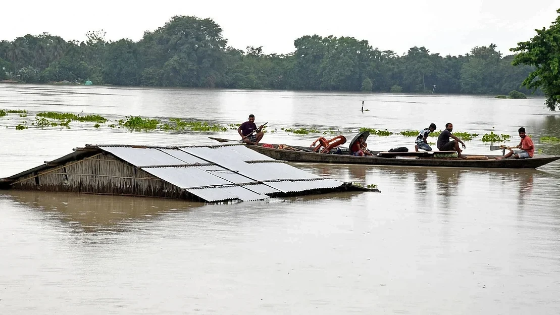
Meteorological Department (IMD), Pune, rainfall over Assam and Meghalaya was
the highest in June in 121 years with 858.1 mm, breaking the previous record of
789.5 mm recorded in 1966. However, rainfall over Kerala and Mahe was the
fourth lowest since 1901, with only 308.7 mm.
The survey also indicated that strong
rainfall and lightning in the first month of the monsoon caused over 313
fatalities, 72 injuries, 50 unaccounted-for deaths, and over 72,000 cattle
losses.
Out of these, landslides, torrential rain,
and flooding caused 191 people to pass away; 8 people to be hurt; 50 people to
go missing; and 72,672 animals to perish.
The
northeastern states of Assam, Arunachal Pradesh, Meghalaya, and Manipur (Noney
landslide) saw the greatest number of flood-related fatalities, whereas Bihar,
Andhra Pradesh, Maharashtra, Uttar Pradesh, and Madhya Pradesh saw the greatest
number of lightning-related fatalities.
The average maximum, minimum, and mean
temperatures for the entire nation during June 2022 were 34.12 degrees Celsius,
25.06 degrees Celsius, and 29.59 degrees Celsius, respectively, in contrast to
the typical values of 33.73 degrees Celsius, 24.76 degrees Celsius, and 29.25
degrees Celsius based on the period of 1981–2010.
As a
result, the country's mean temperature, average maximum temperature, and
average minimum temperature were all 0.40 degrees Celsius, 0.29 degrees
Celsius, and 0.35 degrees Celsius higher than average. Although early June had
significant heat stress in some areas of northwest India, the average
temperature may not have reflected the extremes because of pre-monsoon showers.
In the last 121 years, the northwest of India experienced the 33rd-highest
maximum temperature and the 25th-lowest minimum temperature.
According
to the climate summary, June's rainfall was distributed very unevenly.
Only two low pressure system days were
recorded in June, compared to the average of 10.24, since only one low pressure
system occurred over the Arabian Sea on June 27 and 28. In many areas of the
country, the monsoon season's low-pressure systems are a major cause of
significant and extremely high rainfall.
The
analysis stated that the lack of rainfall over the central Indian region in
June was primarily due to fewer low-pressure systems.
In
2021, seven low-pressure systems that produced heavy rainfall in June formed.
However, a number of weather stations, including Mawsynram, Forbesganj,
Srinagar Aero, Batote, Mahabalipuram, Mysore, Silchar, and Najibabad, set new
records for June rainfall this year.
The country as a whole recorded 152.3
millimetres of rainfall in June 2022, which is 8% less than its Long Period
Average (LPA) of 165.3 mm.
Central India experienced a 30% shortfall in
rain, compared to a 12% deficit in the northwest, a 14% deficit in the southern
peninsula, and a 22% surplus in the east and northeast.
One of the main causes of the uneven
distribution of rainfall in June was the lack of low-pressure systems, which
are crucial for bringing rain to central India. Patchy rains in India were
caused, in part, by the Madden Julian Oscillation (MJO) being in an
unfavourable location for rainfall and low typhoon activity across the
northwest Pacific, according to OP Sreejith, head of the climate monitoring and
forecast group at IMD, Pune.
The
majority of weather fluctuations in the area, including the south-west and
north-east monsoons, are caused by the MJO, a band of rain clouds that sweeps
eastward over the tropics.
It's interesting to note that the data did
not represent the extremely high temperatures that northwest India saw in June.
"That is because there weren't many days
with a heat wave and the rest of the time the temperature was normal."
Sreejith continued. Temperatures were generally near normal or slightly above
normal across the nation.
According
to the Earth System Science Organization's (ESSO) and IMD's Seasonal Climate
Outlook for South Asia, the equatorial Pacific is currently experiencing La Nia
conditions. The monsoon season is likely to be marked by La Nia conditions. In
some areas of the far northwest, north, and southeast Asia, the probability
forecast for precipitation in June, July, and August indicates a higher
likelihood of below-average rainfall, while the remainder of South Asia is more
likely to see above-average precipitation.
Except for a few spots in the northwest, west,
and northeast peninsular regions of South Asia where there is a moderate
probability of above-normal temperatures, the probability forecast for
temperatures for the season indicates a higher probability of below-normal
temperatures over most of South Asia. Most of central and some areas of
southeast Peninsular India, together with the majority of north India's
Himalayan plains, are forecast to see below-average temperatures.
On Tuesday and Wednesday, broad and intense
rains persisted throughout the west coast and central India.
Extremely
heavy rainfall (over 20 cm) occurred over a number of locations in Coastal
Karnataka, West Madhya Pradesh, Konkan & Goa, and Madhya Maharashtra. Heavy
to very heavy rainfall (11.5 to 20 cm) also occurred over Telangana, Odisha,
Gujarat State, Assam, Meghalaya, Kerala, Mahe, Tamil Nadu, Puducherry,
Karaikal, and South Interior Karnataka, and heavy rainfall at isolated
locations.
The
low-pressure area that developed over Odisha on July 3 is now over Kutch and
the surrounding area, and the cyclonic circulation it is associated with has
reached mid-tropospheric levels. Over the next 24 hours, it is most likely to
continue moving westward and lose some of its prominence. The monsoon trough is
vigorous and farther south than usual. It is highly possible that starting
tomorrow, its western end will progressively shift northward.
At mean sea level, there is an east-west
shear zone. At mean sea level, a trough extends from the Gujarati coast to the
Karnataka coast. Additionally, there is a cyclonic circulation over northern
Odisha and neighbouring Chhattisgarh.
Continue Reading